Cala Peña Rotja (29)
Cala Font Salada (30)
Cala Matsoch (31)
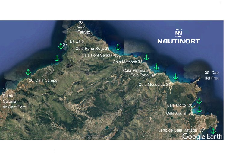
Cala Mitjana (32). It is located in the municipality of Artá. It is also called Sa Duaia and s'Aduaia. It consists of a small beach of fine sand about 90 m long and up to 100 m wide. Two low rocks form its ends, while its back is a small dune system (protected) populated by thistles and junipers. It’s a good place to anchoring. Once the wide mouth is overcome the cove is divided into two arms of sea. The left has a depth of up to nine meters on a bottom of sand and rock. The right, which overlooks the beach, has up to five meters on sandy bottom. GPS position 39º 45,17" 71" N 3ª 24,44'12"E, 18,67 miles from our dock. Estimated speed of arrival at 22 knots - 52 minutes.
Cala Torta (33) This beautiful sand between low rocks and mountains of thyme, mastic, very palm and few pines comes from a not very prominent incoming sea that dies in a dune system. This rugged beach has a lot of slope, as evidenced by the fact that it suddenly stops making foot, fruit of the wind with great waves that hits the coast of Artanense. And the fact that Cala Torta enters very little on land causes it to be exposed to the winds of northwest, north, northeast and this. It is an excellent place for diving, as well as for anchoring boats, on a sandy bottom, five meters deep, in a maneuver that requires the utmost concerns. Due to the morphological arrangement and exposure to the winds of this beach, attention should be paid to the weather conditions for anchoring boats. GPS position 39º 45,02" 99" N 3ª 25,06' 79" E, 18,85 miles from our dock. Estimated time of arrival at 22 knots - 54 minutes.
Cala Mesquida (34) It is a beach of fine white sand located in the municipality of Capdepera. The sand is almost 350 m long, flanked by rocks at both ends, and slightly more than 70 m wide in its wider area. The back of the beach is an extensive dune system on which pine and mastic grow. Anchoring in the bay is complicated by the currents that push boats ashore and makes it difficult to get out to sea. In any case, if the sea is calm, away from the beach there are five meters deep on sandy bottom. It is not possible to approach the shore by the shallow depth. GPS position 39º 44,43" 05" N 3ª 26,05' 39" E, 19,64 miles from our dock. Estimated time of arrival at 22 knots - 54 minutes.
Cap del Freu (35) It is located between the towns of Artà and Capdepera, comprising two areas of coastal cliffs at the northern end of the Llevant peninsula. Nature reserve. Glorious wild landscape. Anchoring It is a good place to anchor a boat Good grip on clean and extensive sand. Plenty of space. Exposed except west, southwest and south. GPS position 39º 44.54" 48" N 3ª 27,39' 21" E, 20,05 miles from our dock. Estimated time of arrival at 22 knots - 58 minutes.
Cala Moltó (36) It is a tiny rock cove very close to Cala Ratjada, in the municipality of Capdepera. The accessible area on foot is barely 30 m long and up to 3 m wide. The cove is exposed to east and northeast winds, and can change rapidly, so the sea can sting in a short time. The bottom is sandy with some areas of posidonia, so if the sea is calm you can walk on a relaxing sandy bed. It offers good protection from south and west winds, but is exposed to east and northeast component. Winds often change sharply, and mudslides are not uncommon for anchoring too close to rocks and not anticipating wind changes. GPS position 39º 43,24" 20" N 3ª 27,21' 79" E, 22,11 miles from our dock. Estimated time of arrival at 22 knots - 1.05h.
Cala Agulla (37) It is a sandy and rocky beach located in the municipality of Capdepera. If it blows from the west, the beach widens, and if it blows from the east, it narrows. It is located within a Natural Area of Special Interest, which has limited the urbanization of the environment, keeping it practically virgin. The depth is about 5 m, but it is advisable to anchor only when there is calm sea or winds between the south and northwest sectors. If winds blow between north and east, anchoring in the deep sea is discouraged. The nearest marina is Cala Ratjada, 2.5 miles, on the other side of the small cape where Cala Agulla is located. GPS position 39º 43,24" 20" N 3ª 27,21' 79" E, 22,11 miles from our dock. Estimated time of arrival at 22 knots - 1.05h.
Cala Rayada Port (38) It is a paradise for those who arrive with a boat. In the place you will find very little crowded beaches and some spaces such as the lighthouse of Capdepera. We must be careful to watch the place chosen to anchor because it is a rocky area of difficult access, although parts such as Cala Guya are very comfortable for any sailor. GPS position 39º 42,32" 84" N 3ª 27,46' 19" E, 29 miles from our dock. Estimated time of arrival at 22 knots - 1.25h