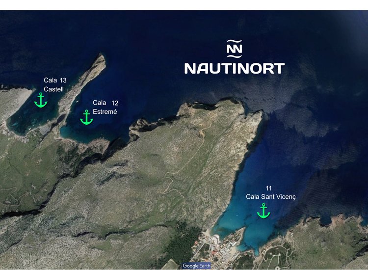
Cala Barques (11) is separated from Cala Clara by Punta dels Ferrers and is part of the four beaches called Cala Sant Vicenç, being the largest and most touristic of the whole. This beach surrounded by holiday establishments and residential homes preserves its seafaring past with the maintenance of its small jetty. The marine and underwater conditions are suitable for anchoring boats, provided that a slab covered by less than one meter of water, detected 200 meters from the shore, and the north-northeast winds that channel the sea are avoided. GPS position 35º 55,29’, 58” N 3º 04,02’ 17” N, 15,54 miles from our dock. Estimated speed of arrival at 22 nots – 45 minutes.
Cala Estremer (12) is flanked by the high vertical cliffs of Punta del Àguila, where there is an eight-metre-high grotto that overlooks the sea, and the rugged cliffs of Punta Galera. This deep sea inlet, shaped "U", dies at the mouth of several torrents, one continues to flow water in summer from a ravine overlooking the Mediterranean, forming a small virgin beach, of wild beauty. Stones, boulders and gravel replace the sand. Its marine and underwater conditions are not recommended for anchoring boats before the possibility of grounding, event that would be aggravated by the great depths that are reached to touch the stony bottom of this stretch of the pollençí coastline, as well as the scourge of the north -northeast wind. GPS position 39º 55,50’ 13” N 3º 02, 19,69” E, 16,27 from our dock. Estimated speed of arrival at 22 nots – 48 minutes.
Cala Castell (13) is between the brittle rugged cliffs of Punta Galera and the bare cliffs of Punta Topina. This beautiful wild beach originates at the end of a ravine, dividing into two coves, whose substrate is formed by round edges, gravels, sand and remains of posidonia algae. Its marine and underwater conditions are suitable for anchoring a boat, whose safety is reduced when the north wind blows. GPS position 39º 55,53’ 23” N 3º 02,09’ 59” E, 16,61 milles from our dock. Estimated speed of arrival at 22 nots – 48 minutes.