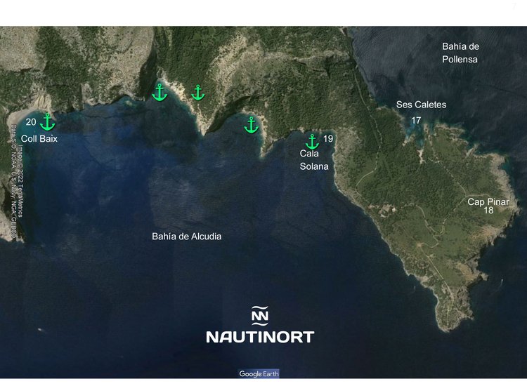
Ses Caletes (17) It is a set of small coves located in Pinar Cape, a military zone managed by the Ministry of Defense. It can only be accessed by sea or with a special permit. This coastline is suitable for anchoring boats, but you have to stay 250 meters from the shore because it is a military zone. Coves without services. GPS position 39º 53,11' 42" N 3º 11,19'88" E at 5,07 miles from our dock. Estimated speed of arrival at 22 knots - 16 minutes.
Cabo Pinar (18) is on the northern coast of Mallorca (Alcúdia), at the end of the peninsula des Pinar, which separates the bays of Alcúdia and Pollença. Along the perimeter of the peninsula the coast is rough and rugged, with prominent cliffs in some places. From the sea you can see a charming and cozy corner of fine sand surrounded by lush and beautiful pine trees. Between them appears a cove (sa caleta des capità) of barely 25 meters of length and 20 of width. The waters of Cabo Pinar are blue-green and invite us again and again to swim and enjoy this idyllic and natural corner in the middle of the Mediterranean. This coastline is suitable for anchoring boats whose safety is reduced when the east wind blows. GPS position 39º 53,37' 33 N 3º 11,42' 65" E, 5,29 miles from our jetty. Estimated speed of arrival at 22 knots - 17 minutes.
Cala Sa Solana (19) is located southwest of Cap des Pinar, and north of Coll Baix. In this beautiful cove you can anchor boats between three and eight meters on a beautiful white sand background. Although it has to be financed with caution by the rocky margins that wrap the cove. GPS position 39º 52,52' 13" N 3º 11,21' 18" E, 6,83 miles from our jetty. Estimated speed of arrival at 22 knots - 19 minutes.
Coll Baix (20) is a beach of gravel and thick lead-colored sand. It is a wide and rectilinear incoming sea that ends in a spectacular beach, flanked by some impressive rocky cliffs in slope and closed by an embankment of considerable height, whose collapses originate this sand. This environment is guarded at 445 meters high by a defensive tower of the sixteenth century, sa Talaia d'Alcúdia or Victòria, which overlooks the bays of Alcúdia and Pollença. The anchoring of boats should be done at a certain distance from its shore, since a scarce depth of the sea is detected. Far from the coast there is a draft of about five meters, on a bottom of rock and sand. This beach is the first refuge available between Cap des Pinar and the wild Cap de Menorca. Port d'Alcúdia is 4.8 miles away. GPS position 39º 51,451 14" N 3º 11,12' 93" E 22 minutes from our jetty. Estimated speed of arrival at 22 knots - 22 minutes.